Forensic Anthropology Vol. 5, No. 3: 251–261
RESEARCH ARTICLE
Adaptation of the Weldon Spring Protocol as a Proposal for the Search for Cadavers and Evidence in Protected Natural Areas and Areas of Ecological Conservation in Mexico City
Lorena Valencia Caballeroa ● Erica Itzel Landa Juárezb,a*
ABSTRACT: The institutions responsible for administrating and providing justice in Mexico City lack the methodology, techniques, protocols, and highly trained personnel to carry out the search for disappeared persons. Neither a structure nor organization exist to carry out this work. To avoid continuing to act solely empirically, we decided to propose a model for searching for human remains and surface evidence. We took as a guide the knowledge and experience of the Weldon Spring protocol, which was created, adopted and applied in the United States for cases of mass disasters.
The adaptation of this protocol to Mexico City is focused on the protected natural areas and areas of ecological conservation, since they are the zones where human bodies are most likely deposited, a product of crimes carried out by urban organized crime groups. Those areas are located in the higher and more remote parts of the city, and in addition they lack illumination, modes of transportation, public services and security; and they constitute 23.7% of the land under conservation.
With this model we stress the importance of developing solid work team; knowledge of natural areas and how urban organized crime is constituted; and the need to carry out prospecting remotely and on foot. It is also important to create a route organized in transect lines and to consider the social and economic impact of using current technological tools to geo-reference the site and the implementation of index cards to register events.
KEYWORDS: forensic archaeology, Mexico City, search
Introduction
The proposal we are making seeks to contribute to, propose a field protocol to conduct scientific and systematized searches for unidentified human bodies on the surface of natural sites that are difficult to access in Mexico City. No model or action protocol for the search for human bodies and evidence on the surface has been developed so far. The forensic archaeologist and forensic anthropologist exert little influence on investigative processes, even though the number of disappeared persons in the country is alarmingly high. As a result, it is imperative to propose an action model that may be useful for specific geographic, environmental, and social characteristics, especially considering the criminal behavior that occurs in Mexico City.
We take up the Weldon Spring protocol, given that it is a model that researchers have studied, experimented with, verified and certified for mass disasters in the United States. As such, we focus on its steps and phases to adapt and apply them to extensive geographic areas and the hills, valleys and plains that make up the protected natural areas in Mexico City.
These areas are found in high places with low temperatures and are sparsely populated. They have little access to public services and security. Most importantly, these areas are where bodies of victims of violent killings are found, acts carried out by individuals but also by organized crime groups that operate in the city’s interior and surrounding urban areas.
The proposal for the searches that we offer is divided into two parts: the first is preparation that the teams undertake, and the second is the location, documentation and recovery of evidence. The second part is divided into three phases. Phase I corresponds to the written documentation through narration, a photographic record and video without sound; Phase II corresponds to the activities of the search team through remote prospecting and on foot, exploring in transect lines; finally, Phase III focuses on the recovery of potential evidence and the documentation on index cards of body parts, bones, a narrative record, and the photographic record (see Annex).
We are convinced that with the application of this search model, which meets scientific standards, government institutions will obtain satisfactory results that are fair and viable for victims’ families, judges and society.
History of the Weldon Spring Protocol
At the end of 1990, the forensic archaeology protocol which was developed specifically for open spaces public places and in large-scale disaster situations where environmental diversity and evidence interact, was modified.
In 2000, the protocol was tested in an effort supervised by highly trained, professional personnel of the Federal Bureau of Investigation (FBI), in a place called Weldon Spring located in eastern Missouri, United States (Dirkmaat 2012). The Weldon Spring protocol proved to be quantifiably better with respect to various factors: the number of items of potential evidence collected; in establishing the three-dimensional record of each item’s location and carrying out the investigation in a single day of work.
Over time, specific criminal circumstances, technological advances and tests carried out in controlled conditions have brought about changes in the protocol. However, these changes have facilitated the credibility and practicality of the protocol when it is applied. In 2009, when flight 3407 was heading toward the Buffalo Niagara international airport, it collided with a house in the suburbs of Clarence Center in New York state. The 49 passengers on board and one person who was nearby died. Facing this situation, researchers drew on the Weldon Spring protocol. It was an opportunity to make changes and integrate the guidelines for using a total station for the assignment of anatomical points of the human body that should be considered (Dirkmaat 2012).
In Wattsburg, Pennsylvania in 2009, an exercise in a controlled environment was carried out in which researchers simulated an environment following the explosion of a bomb in an open space. The purpose of the exercise was to compare two documentation processes. There were two teams that performed the same activities, but with different work tools. One team was assigned a transect corridor, and it also used bar codes and hand-held computers or tablets; the other team, in another transect corridor, was assigned the total station and manual registration. At the end of the exercise, researchers calculated which of the two teams took less time to conclude its investigation. In addition, thanks to this exercise the formation of two photographic record teams was recommended (Dirkmaat 2012).
In the same year, in Williamsport, Pennsylvania, researchers performed another exercise in which a bomb was detonated in a car that contained a pig. During this exercise, researchers included bar codes, several total stations and the simultaneous connection to a mobile military telephone and a computer.
In 2010, in Erie, Pennsylvania, the third exercise using detonations of car bombs was carried out, with the purpose of testing and making changes in the protocol to verify its utility and practicality.
After these exercises, Global Positioning System (GPS) and Global Navigation Satellite System (GNSS) units were implemented, which reduced the time required to collect objects by 300%. The third modification was to add a second “photography team” and a second “collection team” (Dirkmaat 2012).
The protocol will continue undergoing changes, according to technological advances and site-specific needs; for instance, real time spatial analysis using a Geographic Information System (GIS) is anticipated.
The Weldon Spring protocol could be adapted to the different geographic context of Mexico City to guide a search for evidence on the ground surface. To carry this out, it is necessary to adapt the protocol to the city’s natural areas; to consider the lack of security for those carrying out the search; and knowledge about how specific criminal groups operate. Also, researchers must keep in mind the lack of technology and budget from which the city suffers.
Protected Natural Areas and Areas of Ecological Conservation in Mexico City
The natural areas protected and ecologically preserved in Mexico City are those natural physical spaces where human activities have not significantly altered the original environments, or that require preservation and restoration due to their structure and the role they play in the preservation of biodiversity and environmental services.
In Mexico City 23 Protected Natural Areas (ANPs, for their initials in Spanish) have been created by decree, seven of which are National Parks administered by the National Commission of Protected Natural Areas (CONANP). The total surface area of the local ANPs is 21,047.01 hectares, which represent 23.79% of conservation lands in Mexico City.
These areas are protected to conserve natural resources that are of special importance, whether they are fauna or flora that are categorized as being at various levels of risk (rare, threatened, endemic, in danger of extinction) or local-level representative ecosystems (sedema.cdmx.gob.mx).
This 23.79% of protected natural resources are found away from urban areas, are not easily accessible. They lack public services, particularly security, which makes them ideal places for dumping human bodies.
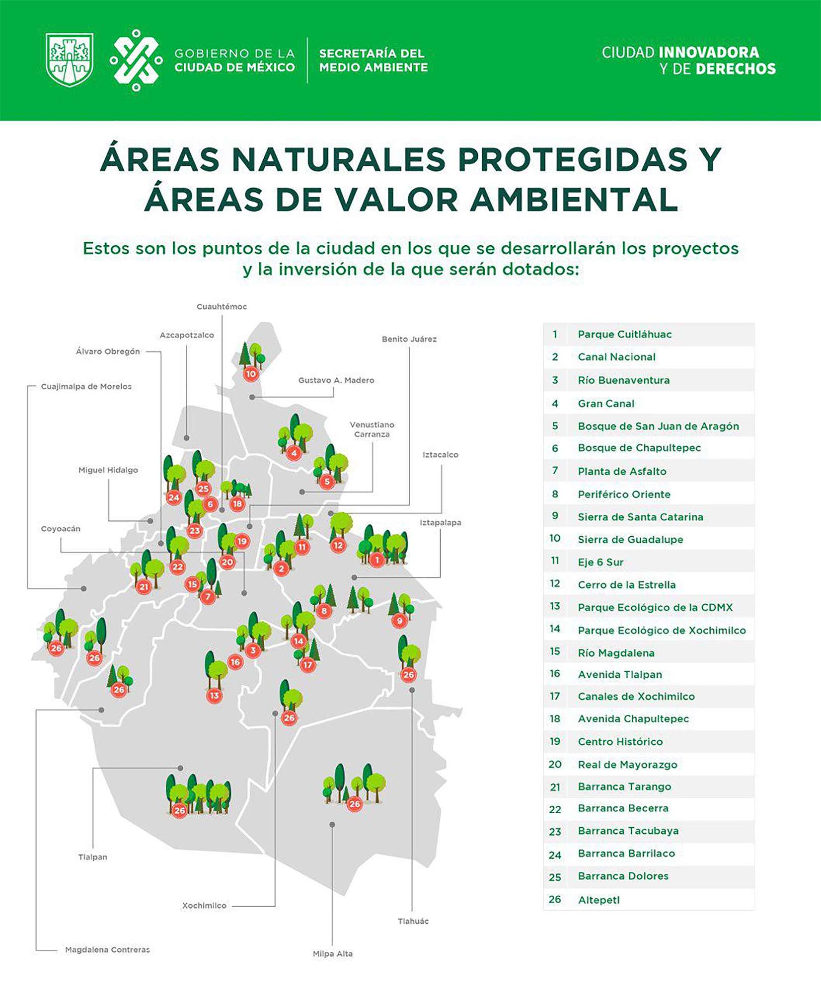
The Secretary of the Environment of Mexico City (Sedema), which was founded in 1997, is an agency administered by the government of Mexico City, which has under its authority the protection of the environment to promote sustainable urban development. This department carries out inventories of protected natural areas and community areas under ecological conservation (Figure 1).
Each area has a name, the date when it was declared a protected natural area, and the inventory provides its location, area in hectares, and the administrative department in charge of its maintenance and care. These can be in a mayor’s office, public lands, in the community, in a commission like the General Management of the Natural Resources Commission (DGCORENA), or in the Secretary of the Environment and Natural Resources (SEMARNAT). Finally, the type of vegetation present in the area is also noted (see Tables 1-6).
Urban Organized Crime and Criminal Organizations
Urban organized crime may be understood as a group of individuals dedicated to illicit activities to generate income focused on the city but sometimes with transnational connections. In general, these groups operate with a local boss, little hierarchy and centralization of activities and roles. Illegal organizations confront specific transaction costs that they try to cover with activities that range from tax evasion to coopting the state. Some are very competitive in dynamic markets like the drug trade. To sustain themselves, they have to combine activities like extortion or kidnapping, human trafficking, migratory networks, entertainment markets, tourism, or real estate (Alvarado 2014).
At the beginning of the 1980s organized crime surged in Mexico City due to the forced displacement of families caused by the arrival of massive industries and businesses from different countries that bought large quantities of agricultural land at low cost, leaving peasants and local small-scale businesspeople without work. So, the families that were living in Michoacán, Guerrero, Oaxaca, Chiapas Tabasco and Veracruz had to leave their belongings and homes to relocate to Mexico City and start an economic life different from that to which they were accustomed.
The families rebuilt their lives in the city, settling in shantytowns and opening convenience stores to supply their neighbors. However, the first generation born in these neighborhoods worked informally, selling electrical appliances and clothing, products that came from the United States and which they sold at very low prices. This economic activity benefited this generation because its members made large profits, but they later became victims of extortion by other businesspeople, police, or criminal groups. In response, some of them decided to organize and confront these groups, creating organizations that operated violently and outside of the law.
By the end of the 1980s, urban criminal groups were organized, and they had territorial control, a considerable number of members, hierarchical relations, and a range of disparate illicit activities (Alvarado 2014).
As the years passed, these organizations specialized, and now two kinds of groups dedicated to illicit activities operate— transnational and retail. Both groups engage in large-scale violence, evident in rates of violent deaths and disappearances (Alvarado 2014).
The criminal groups that operate in the city are La Familia Michoacana in the boroughs Venustiano Carranza, Iztacalco, and Gustavo A Madero; and in the towns of Huixquilucan, Naucalpan and Tlanepantla.
The Jalisco Nueva Generación cartel and the Juárez cartel operate in the borough of Miguel Hidalgo; Los Rodolfos in the south of the city and the state of Mexico; the Unión de Tepito in the settlement (colonia) of Morelos, and the boroughs Cuauhtémoc, Azcapotzalco, Venustiano Carranza; the Fuerza Anti-Unión in the Morelos settlement, and the boroughs of Cuahtémoc and Azcapotzalco; the cartel of Tláhuac in boroughs of Tláhuac, Xochimilco and Milpa Alta; the Beltrán Leyva cartel in the South of Mexico City, borough of Tlalpan, towns of Ecatepec and Texcoco (El Metro, El Gráfico, El Universal, La Jornada, La Razón, La Crónica, Reporte Índigo, Milenio y La Prensa 2017-2018).
The magnitude of criminal activities is notably greater than in any other city in the region. These include car theft, retail drug dealing, piracy, sex trafficking, homicides and executions. The case of Mexico City involves a rate of violent deaths much higher than the average in other locations.
Incidence of Homicides in Mexico City from 2015 to 2018
The need for a model for searching for dead bodies is urgent because the rates of femicide and homicide are continually increasing as the years pass. This information comes from the Statistical Bulletin of the Incidence of Crime in Mexico City, which is published by the Government of Mexico City or CDMX and the Attorney General’s Office.
According to published statistics, from January to December 2015, the number of homicides, including femicides was 854 people, a daily average of 2.3 people; in 2016 homicides including femicides reached 952 people, meaning a daily average of 2.6; in 2017 intentional homicides including femicides reached a total of 1,085 cases, a daily average of 3.0 homicides. The 2018 statistical report documents an increase to 1,265 homicide cases and a daily average of 3.5 homicides (http: www.pgjcdmx.gob.mx).
FIG. 1—Map from the government of Mexico City, Secretary of the Environment. Natural protected areas and areas of environmental value.
TABLE 1—Inventory of Protected Natural Areas and Communal Ecological Conservation Areas in Mexico City according to SEDEMA (Secretary of the Environment).
|
Number |
Name |
Date of decree |
Location |
Area in hectares (ha.) |
Administration |
Type of vegetation |
||||||
|
1 |
Cumbres del Ajusco. |
May 19, 1947, Diario Oficial. |
Tlalpan Delegation. |
920.00 |
DGCORENA |
Pine and oyamel fir forest. |
||||||
|
2 |
Desierto de los Leones. |
November 27, 1917, Diario Oficial. |
Cuajimalpa and Álvaro Obregón Delegations. |
1,529.00 |
DGCORENA |
Oyamel fir- pine- oak forest and pastures. |
||||||
|
3 |
Insurgente Miguel Hidalgo y Costilla. |
September 18, 1936, Diario Oficial. |
Cuajimalpa Delegation and in the municipalities of Ocoyoacac, Huixquilucan in the State of Mexico. |
1,836,336 of which only 336.00 ha. are in CDMX. |
SEMARNAT |
Oyamel fir, pine forest. |
||||||
|
4 |
Cerro de la Estrella. |
August 24, 1938, Diario Oficial. |
Iztapalapa Delegation. |
1100.00 |
SEMARNAT |
|||||||
|
5 |
El Tepeyac. |
February 18, 1937, Diario Oficial. |
Gustavo A. Madero Delegation. |
1,500.00 |
SEMARNAT |
Xerophilous brush and artificial eucalyptus, pine and cedar forest |
||||||
|
6 |
Fuentes Brotantes de Tlalpan. |
September 28, 1936, Diario Oficial. |
Tlalpan Delegation. |
129.00 |
Tlalpan Delegation. |
|||||||
|
7 |
Lomas de Padierna. |
April 22, 1938, Diario Oficial. |
Magdalena Contreras Delegation. |
670.00 |
SEMARNAT |
Artificial cedar forest. |
||||||
|
Subtotal |
6,184.00 |
TABLE 2—Zones under ecological conservation.
|
Number |
Name of order |
Date of order |
Location |
Area (ha) |
Administration |
Type of vegetation |
||||||
|
1 |
Cumbres del Ajusco. |
May 19, 1947. Diario Oficial. |
Tlalpan Delegation. |
920.00 |
DGCORENA |
Pine and oyamel fir forest. |
||||||
|
2 |
Desierto de los Leones. |
November 27, 1917, Diario Oficial. |
Cuajimalpa y Álvaro Obregón Delegations. |
1,529.00 |
DGCORENA |
Oyamel fir- pine- oak forest and pastures. |
||||||
|
3 |
Insurgente Miguel Hidalgo y Costilla. |
September 18, 1936, Diario Oficial. |
Cuajimalpa Delegation and in the municipalities of Ocoyoacac, Huixquilucan in the State of Mexico. |
1,836,336 of which only 336.00 ha. are in CDMX. |
SEMARNAT |
Oyamel fir forest, pine forest. |
||||||
|
4 |
Cerro de la Estrella. |
August 24, 1938, Diario Oficial. |
Iztapalapa Delegation. |
1100.00 |
SEMARNAT |
|||||||
|
5 |
El Tepeyac. |
August 24, 1938, Diario Oficial. |
Gustavo A. Madero Delegation. |
1,500.00 |
SEMARNAT |
Xerophilous brush and artificial eucalyptus, pine and cedar forest |
||||||
|
6 |
Fuentes Brotantes de Tlalpan. |
September 28, 1936, Diario Oficial. |
Tlalpan Delegation. |
129.00 |
Tlalpan Delegation |
|||||||
|
7 |
Lomas de Padierna. |
April 22, 1938, Diario Oficial. |
Magdalena Contreras Delegation. |
670.00 |
SEMARNAT |
Artificial cedar forest. |
||||||
|
Subtotal |
4, 438.013 |
TABLE 3—Ecological conservation zones.
|
Number |
Name |
Date of order |
Location |
Area (ha) |
Administration |
Type of vegetation |
||||||
|
1 |
Ecoguardas. |
November 29, 2006, Gaceta Oficial del D.F. |
Tlalpan Delegation. |
132.63 |
SMA |
Oak forest and xerophilous brush. |
||||||
|
2 |
Sierra de Santa Catarina |
August 21, 2003, Gaceta Oficial del D.F. |
Iztapalapa and Tláhuac Delegations. |
220.55 |
DGCORENA |
Pasture, xerophilous brush. |
||||||
|
3 |
La Armella. |
June 9, 2006, Gaceta Oficial del D.F. |
Gustavo A. Madero Delegation. |
193.38 |
DGCORENA |
Xerophilous brush and artificial eucalyptus, pine and cedar forest. |
||||||
|
4 |
La Loma. |
April 20, 2010, Gaceta Oficial del D.F. |
Álvaro Obregón Delegation. |
77.33 |
DGCORENA |
Oak forest. |
||||||
|
Subtotal |
623.89 |
TABLE 4—Ecological and cultural zones.
|
Number |
Name |
Date of order |
Location |
Area (ha) |
Administration |
Type of vegetation |
||||||
|
1 |
Bosque de Tlalpan. |
June 17, 2011, Gaceta Oficial del D.F. |
Tlalpan Delegation. |
252.86 |
Tlalpan Delegation. |
Oak forest, xerophilous brush, artificial eucalyptus, cedar y ash tree forest. |
||||||
|
2 |
Cerro de la Estrella. |
November 2, 2005, Gaceta Oficial del D.F. |
Iztapalapa Delegation. |
121.77 |
Iztapalapa Delegation. |
Artificial eucalyptus-cedar forest and relicts xerophilous brush. |
||||||
|
Subtotal |
374.63 |
TABLE 5—Communal ecological reserves.
|
Number |
Name |
Date of order |
Location |
Area (ha) |
Administration |
Type of vegetation |
||||||
|
1 |
San Nicolás Totolapan. |
November 29, 2006, Gaceta Oficial del D.F. |
Magdalena Contreras y Tlalpan Delegations. |
1,984.70 |
Public land |
Oyamel fir-pine-oak forest and pastures. |
||||||
|
2 |
San Miguel Topilejo. |
June 26, 2007, Gaceta Oficial del D.F |
Tlalpan Delegation. |
6,000.29 |
Community |
Oyamel fir forest, pine forest, pasture. |
||||||
|
3 |
San Bernabé Ocotepe. |
June 21, 2010, Gaceta Oficial del D.F. |
Magdalena Contreras y Álvaro Obregón Delegations. |
240.38 |
Community |
Oak-pine-fir forest, oyamel fir forest, pine forest. |
||||||
|
4 |
San Miguel Ajusco. |
November 16, 2010, Gaceta Oficial del D.F. |
Tlalpan Delegation. |
1,175.99 |
Community |
Oyamel fir forest, pine forest, pasture. |
||||||
|
Subtotal |
9,401.36 |
TABLE 6—Hydrological and ecological protection zone.
|
Number |
Name |
Date of order |
Location |
Area (ha) |
Administration |
Type of vegetation |
||||||
|
1 |
Los Encinos. |
December 1, 2009, Gaceta Oficial del D.F. |
Tlalpan Delegation. |
25.01 |
DGCORENA |
Oak forest, xerophilous brush. |
This situation demands that innovative protocols, methods, and techniques be established and adapted to the social needs of Mexico City.
From Weldon Spring, Missouri to Mexico City
In her undergraduate thesis in archaeology, archaeologist Andrea Muñoz has proposed modifications for adapting the Weldon Spring protocol to Mexico. We take up the proposed changes so that they can be applied to natural and ecological protected zones in Mexico City.
This new protocol is composed of three phases and six steps to follow. It emphasizes the composition of the teams that will work together covering the route on foot, the activity of walking in a straight line through the site accompanied by the search team, which has the task of observing the site and identifying objects. They immediately place a marker near each piece of potential evidence. Subsequently, the recovery team uses an electronic total station to specify geographically each point indicated by the search team. At all times the photography team’s register is available, which documents the indicated items. Each photo has a scale of 1:10, indicates north with an arrow and includes a metric scale. Afterwards, the recovery team collects the human remains and brings them to the Institute of Forensic Sciences (INCIFO, its acronym in Spanish).
The protocol has three priorities which it must fulfill (Muñoz 2014), which are the following:
Priority 1. Locate, document and recover human remains without mixing or disassociating them, carrying out an effective and efficient location and recovery strategy.
Priority 2. Locate, register and recover the associated objects, carefully documenting their spatial relationship with the human remains.
Priority 3. Document and register everything that can be observed from the site to obtain the best possible contextual information. This contributes to the investigation and helps reconstruct events, which will explain the behaviors that produced these scenes.
Preparation
A. Establish a strong chain of communication among specialists to take maximum advantage of their knowledge and resources.
Once the area in Mexico City to be investigated is designated, the forensic archaeologists, forensic anthropologists, criminalists, photographers, as well as the investigative police and the public prosecutor’s office should meet to share information related to the case, so that the experts and police become familiar with the context in which the search will unfold and can plan accordingly.
B. Determine the physical characteristics of that being sought.
The forensic anthropologists should have knowledge of antemortem/postmortem (AM/PM) interviews. This interview contains the information obtained by the forensic anthropologist through the skeletal analysis of the remains or corpses (postmortem), and this is compared with the information about the observable characteristics of the person when he or she was alive (antemortem). For the comparison to provide reliable results, the antemortem information should be expressed in a way that is comparable with the postmortem information (Mejía and Palma 2018).
For this reason, the anthropologists should know the physical characteristics of the individual(s) for which they are searching, including the sex, chronological age, height, weight in kilograms, and specific physical characteristics such as: scars from injuries, surgeries, tattoos, and dental or orthopedic implements.
C. Determine the accessibility of the wooded site and land.
Before beginning an investigation of the site, a search for written and visual information is carried out regarding the environmental conditions; the climate; the characteristics of the vegetation, meaning the wild flora that grows in different seasons of the year, and the type of fauna; the geology that corresponds to the existing types of soil; the registered average temperature; also it is important to know whether the site to be investigated is located close to any site of historical relevance.
This information will be evaluated to know the limitations of access and/or exit from the site to be able to plan the number of people who will participate, to know if there will be interference with GPS signals, telephone communication, and to know also the meeting points and the area that will be protected by perimeter security (Dirkmaat 2012). In the city’s natural areas, the cordoning is not convenient because the ranges of the search are large, and the team loses time cordoning the area.
Application of behavioral archaeology theory (Codding and Bird 2015; Muñoz 2014; Schiffer 2014) should be considered, which consists of researching the social group that is found close to or surrounding the site of investigation. Knowledge of the history, politics, culture and religion of that population will help to develop the best possible entry and exit strategies, the type of site protection and the security of participants.
D. Establish a Human Remains Tracing System (SRRH, for its initials in Spanish).
This system should assure that potential evidence is properly recorded in writing and through photography and video so that later they can be gathered with the body with which they are related. These records are made with the help of index cards. We propose the human body anatomical record index card; human skeleton anatomical record index card; and narration (before and during the search) record index card; and the photographic record index card (see Annex).
PHASE I. Registration of the investigation site will be carried out by three teams, which will have different tasks. The work is divided this way to speed up the process (Dirkmaat 2012).
Step 1. Initial registration.
A. Narrative team. Develops an initial narrative (IN).
1. General description of site (climate, vegetation).
2. Record activities.
3. Update IN every 30 minutes.
4. Use identity index cards filled out on paper or digitally (preferred).
B. Digital photography team. Carries out general photo-documentation.
1. Photograph the site from the four cardinal directions.
2. Take detailed photos of the site and features of interest.
3. Detailed record of each photograph (cardinal direction from where it was taken and metric scale).
C. Video team. General video documentation of the site.
1. Install video cameras in zones where the largest part of the site and activities carried out in it can be observed and recorded.
2. Record the site and surrounding area in slow motion and with the sound off.
3. The camera can be positioned in different panoramic locations.
4. The team should make a detailed record of the photographs.
Step 2. Preparation of the site for recovery.
The search team performs a remote exploration of the discovery or investigation site (Mendoça 2001), to be able to know the site better during the search route. The team members use tools like topographic maps, aerial photographs of the region with the help of satellite images and 3D images provided by programs like Google Earth, SAGARPA satellite images (including GPS analysis of images), and also if possible, with unmanned aerial vehicles (UAVs) or drones.
2.1. The topographic maps are provided by the National Institute of Statistics and Geography (INEGI), and the majority are at 1:50,000 scale. These maps have topographic, orthographic and hydrographic characteristics, and depict current human settlements and infrastructure projects. Each one covers a total of 960 km² and comprises the national territory in a total of 2025 maps (INEGI 2013).
2.2. In the aerial photographs and satellite images anomalies on the ground that do not seem naturally occurring can be observed and compared with the topographic maps. The purpose of this is to examine carefully if there is evidence of structures and the traces that they leave on the ground. In this phase the area to cover will be demarcated (Muñoz 2014).
The aerial photographs should be vertical, at 90° angles to the ground. They should be taken in intervals so that at least 60% of the previous photograph can be seen in the next photo. This way they can overlap, and the illusion of a third dimension (known as stereopsis) is created with a stereoscope by observing two subsequent photographs. This technique is called photogrammetry. By doing this, researchers can locate patterns on the land that are invisible from the ground. This type of photography is useful because it allows researchers to observe changes on the land due to anthropogenic actions. Anomalies can be located that today are not possible to identify because of demographic growth or natural activity (Muñoz 2014).
2.3. Aerial photographs of 3D images made available by Google Earth pay program (Google Earth Pro). This is an excellent tool that allows satellite views of specific zones that the researcher could need. In addition, these zones are updated every six months to a year, depending on the site. This is an advantage because it allows one to detect the differences on the land if they are compared with information from the SAGARPA satellite or drone images.
The area to investigate is located and georeferenced with Universal Transverse Mercator (UTM) coordinates and with the area selection tool, it provides an approximation of the area to explore in square meters. The disadvantage of this tool is that the images are not in real time and do not necessarily reflect recently altered marks on the vegetation (Muñoz 2014).
2.4. Aerial photographs of 3D images made by the SAGARPA program.
Recent images of Mexican territory can be taken under the SAGARPA satellite agreement. This tool facilitates observation of the ground more precisely and as it is currently (Blancas 2015).
2.5. Unmanned aerial vehicles (UAVs) or a drone (Jensen 1996). Researchers can fly a drone mounted with automated photography equipment to create images that can later be joined to create orthophotography that can be compared to the potential items discovered on scene.
The height at which the drone should fly is perpendicular at two heights, 6 and 12 meters from the ground.
A team leader should be designated who guides, monitors and stops the drone when necessary throughout the search, which will allow team members the opportunity to place small markers close to potential evidence.
PHASE II. Search for evidence and human remains on the ground surface.
Step 3. Establish the primary datum of the site (signal or mark). It should be permanent, if possible.
A. Select area with the greatest visibility.
B. Set up total station, and level and measure the elevation.
C. Create the calibration point.
D. Carry out the prospection route along the ground, which is the process of walking to observe the landscape (Parcak 2009). Researchers should perform a detailed visual examination of the area, paying special attention to possible transformations of the landscape and finding the objects that were previously marked by the team.
E. The route will be realized in transect lines and without marks or connecting lines that physically limit the route, also called “plotless methods” (Parcak 2009), which consists of walking and returning in a straight line, side to side in a rectangular space without putting down stakes. Trees are used as boundaries (Mendoça 2001). This method is employed because it allows for the inspection of a wide area in a single workday without calling for much personnel (Morales & Javir 2000). In addition, this method is useful because the environment involves various animals moving around, the ground will probably be uneven and there will likely be objects on the surface.
PHASE III. Final documentation and recovery.
Step 4. Sweep for potential evidence and human remains. This work should be carried out immediately after the search team finishes its work. Record all spatial information regarding objects and remains.
Registration team (Dirkmaat et al., 2012).
A. The code tagger attaches a label or unique bar code to each marker/pennant.
B. The operator of the code tag (or bar code) reader should scan the code, resend the information to the operator of the GPS via walkie-talkie and create a brief description of the previously registered object.
Step 5. Taking detailed digital photographs.
Photography team (Dirkmaat et al. 2012).
A. The scale, north arrow, and a pennant with visible code are placed together with the object or human remains.
B. The photographs are taken perpendicularly to the ground. Various photos of the same object should be taken that way.
C. The operator of the code tag (or bar code) reader of the photography team scans the code, includes a brief description of the content of the photo and its number and includes it in the database.
D. They will place an × on the back side of the photographed pennant, indicating that the object or remains are ready to be recovered.
Step 6. Recovery of objects and human remains. Researchers collect the objects and human remains to begin the chain of custody.
Recovery team (Dirkmaat et al. 2012).
A. Small objects and human remains should be packed in plastic bags and paper respectively (each one in its own bag so they do not mix). The larger remains and objects should be packed into larger containers (cadaver bags for the remains).
B. Place the pennant with the bar code inside the bag (the codes should be waterproof or be placed in another bag so that they cannot fall out or get lost).
C. The duplicate of the bar code that is inside the bag should be pasted outside the bag.
D. The objects and human remains should be handed over to the person responsible for the chain of custody.
This how the application of the Protocol should be carried out in the context of Mexico City (see Table 7).
Conclusions
To date, in the history of criminality and public prosecution in Mexico City, the empirical method has prevailed, and employing science is considered a luxury rather than a necessity. For this reason, field protocols in many areas do not exist, especially in the search for human bodies because until very recently they was not considered necessary.
A forensic archaeological investigation model does not exist for the Attorney General’s Office of Mexico City, nor are there personnel to carry out archaeological work. Without an archaeologist, the forensic anthropologist sometimes does this work when he or she has time for it. Otherwise, in the majority of cases, a firefighter is the person who directs and carries out the work; without devaluing the knowledge and expertise of firefighters, their training does not include familiarity with theoretical behavior models, prospection and excavation techniques, identification of human skeletal remains and taphonomic processes. So, the ideal experts are forensic archaeologists and forensic anthropologists.
TABLE 7—Summary of the application of the Weldon Spring protocol to Mexico City in protected natural areas and areas under ecological conservation.
|
Preparation |
PHASE I. Documentation |
PHASE II. Search |
PHASE III. Recovery |
|||
|
A. Communication. B. Knowledge of persons’ characteristics. C. Precursors of flora, fauna, geology, climate and history of site. D. Prepare index cards. |
Step 1. Narrative, photographic and video teams. Step 2. Search-remote prospection team. |
Step 3. Establish datum and plotless method prospection. |
Step 4. Registration of potential evidence and human remains team. Step 5. Photography of potential evidence and human remains team. Step 6. Recovery of potential evidence and human remains team. |
Source: Erica Itzel Landa Juárez.
Given this situation, we decided to investigate an appropriate model that could be applied in Mexico City. The incidence of people abducted in public streets, from public transport services, whether taxis, combis, microbuses, buses, the metro and even from private cars, who are later killed and abandoned in sites far from the urban centers of the city, has increased enormously and alarmingly. At the same time, these acts are committed as part of robberies, femicide, homicide, kidnapping and human trafficking. These incidents have increased every year and the public prosecutors have been overwhelmed by the situation.
The model that we propose is adapted from the Weldon Spring Protocol, which has been applied in cases of mass disasters in the United States. This protocol has been analyzed, tested, adjusted, verified and certified for use since 1990. As such, it should be considered and adapted to situations that arise in Mexico City, particularly in protected natural and ecological areas of the city, to search for cadavers above ground, even though causes of death may be different from those brought about by massive disasters.
Natural areas make up 23.79% of the area of Mexico City, and they are more likely sites for dumping bodies than the city’s streets, avenues, malls, plazas, kiosks, and bridges. Security cameras would allow the people that commit such violent acts to be identified in such locations, or the existence of witnesses would impede them from committing the crime. As such, this is a vast area in which to hide human bodies. These areas are difficult to access, little-explored expanses where wild flora and fauna abound. Even homeless people and criminals rarely decide to enter these areas. All this makes it difficult to carry out investigations.
Moreover, homicides are sometimes perpetrated by one or two people who do not belong to an organized crime group, or in other cases those responsible are people who belong to some of the urban criminal groups that coexist in the city. Many members of these groups have already been identified by name, as well as the identity of the group’s leader, the places where they meet and sometimes the year in which the group was founded.
This information is very important. Also, we know that the principal characteristic of urban groups is their interest in the retail sector. The retributive behaviors that they employ against the enemy differ from the ways in which rural groups operate. As was mentioned earlier, the retail industry that was established in Mexico City is associated with piracy, drug dealing, car theft, sex trafficking and kidnapping. The protocol that we propose and lay out in the text consists of various well established and defined steps, as well as the activities that each person involved in the investigation team should perform.
Employing this innovative proposal will set a precedent in applying the first protocol for searching for cadavers in natural areas of Mexico City, and it will be beneficial to the institution that investigates and administers justice, especially in its work in support of family members who are searching for a loved one who was abducted and killed without the knowledge of the authorities or relatives.
Using the model proposed here will also provide other information, including: the original location and position of the unidentified body; the identification of postmortem agents that may have scattered the human remains; an explanation for why the biological remains are not where they should have been anatomically; the maximum number of skeletal elements and evidence; better information about how much time the body was on the ground surface, among many other kinds of information.
References
Alvarado Mendoza A. Crimen organizado en una ciudad de América Latina: La Ciudad de México. Quito. Revista Latinoamericana de estudios y seguridad, 2014;19:129–145.
Alvarado N. Sobrinos de mando de la policía de investigación identificados. La Prensa. Noviembre 3, 2017:33.
Alvarado N. No que no, cárteles en CDMX hace 3 o 4 años. La Prensa. Septiembre 12, 2018:3.
Alzaga I. Detienen a El Betito en CDMX y a 2 del cártel de Sinaloa en EU. El Mileno. Agosto 9, 2018:16.
Blancas J., Barba L, Ortíz A., and Carballo D. Percepción remota y prospección arqueológica en la Laguna, Tlaxcala. Revista de Investigaciones Arqueométricas 1(1);2015:1-13.
Blancas D. Unión de Tepito, cártel que controla penales de DCMX. La Crónica. Junio 8, 2017:4.
Codding BF, Bird DW. Behavioral ecology and the future of archaeological science. Journal of Archaeological Science 56;2015:9-20.
Dirkmaat DC. Forensic anthropology at the mass fatality incident (commercial airliner crash scenes). In: Dirkmatt DC, ed. A Companion to Forensic Anthropology. Hoboken, NJ: Wiley-Blackwell; 2012:136–156.
Dirkmaat DC, Chapman EN, Kenyhercz M, Cobo. LL. Enhancing scene processing protocols to improve victim identification and field detection of human remains in mass fatality scenes. National Institute of Justice Document 2No. 238744. Erie, PA; 2012.
Domínguez P. Banda de colombianos roba mata y plagia en 24 estados. Milenio. Agosto 24, 2017:26.
Espinosa A. Abaten al líder de la Unión de Tepito en estacionamiento de GAM. La Prensa. Octubre 12, 2017: 2.
Fondebrider L, Mendoça MC. Protocolo modelo para la investigación forense de muertes sospechosas de haberse producido por violación de los Derechos Humanos. Oficina del Alto Comisionado de las Naciones Unidas para los Derechos Humanos. Proyecto MEX/00/AH/10; 2001.
Instituto Nacional de Estadística y Geografía, 2013.
Jensen JR. Introductory Digital Image Processing: A remote sensing perspective. Hoboken, NJ: Prentice Hall.
Martínez C. Exhiben nexos de Zetas con policías de Papantla. Milenio. Octubre 2, 2017:15.
Mejía JM, Ortega PA. La entrevista a familias en la búsqueda e identificación de personas extraviadas o desaparecidas. Dimensión Antropológica 72(25);2018:141—172.
Morales H, Javir, F. Prospección y excavación: principios metodológicos básicos. In Benítez De Lugo Erich, L.: El patrimonio arqueológico de Ciudad Real: Métodos de trabajo y actuaciones recientes. Ciudad Real: UNED; 2000:355-368.
Muñoz VA. Propuesta metodológica para la búsqueda, excavación, registro y recuperación de cadáveres e indicios asociados en fosas clandestinas. [Licenciatura Disertación]. México: Escuela Nacional de Antropología e Historia; 2014.
Nava F. Amieva pide que el Betito sea enviado a penal federal. La Razón. Agosto 15, 2018:12.
Parcak, S H. Satellite remote sensing for archaeology. Nueva York: Routledge; 2009.
Procuraduría General de Justicia de la Ciudad de México-PGJCDMX. https://www.pgjcdmx.gob.mx. Acceso 23 de agosto 2019.
Ruiz K. Atrapan a sucesor de El Betito en Santa Fé. La Razón. Octubre 31, 2018:17.
Schiffer MB. Behavioral Archaeology: Principles and Practice. New York, NY: Routledge.
Secretaría del Medio Ambiente-SEDEMA. https://www.sedema.cdmx.gob.mx. Acceso 19 de agosto 2019 y 23 de noviembre 2019.
aDepartment of Innovation in Human Biological Material, Medical Faculty, Universidad Nacional Autónoma de México, Coyoacán, Mexico City, Mexico
bAttorney General of Mexico City, Human Identification
*Correspondence to: Erica Itzel Landa Juárez, Attorney General of Mexico City, Human Identification, Avenida Coyoacán 1635, Colonia de Valle Sur, Benito Juárez, C.P. 03104, Ciudad de México, CDMX 06720, México
E-mail: itzeliuras@yahoo.com
Received 02 September 2019; Revised 23 November 2019; Accepted 11 December 2019